Avenzoar was an Al-Andalus wisemen who lived between 1092 and 1162 (according to some sources). He is known because of his knowledge about medicine. Averroes, another important wiseman, was his disciple.
Monday, December 15, 2014
Al-Andalus wisemen: Averroes
CONTEXT

 Averroes
was born when the Almoravids
controlled Al-Andalus. They had crossed the Gibraltar Strait to help the Taifas
kingdoms and they had defeated the Castilians. They extended their control over
Al-Andalus until 1145, when protests against
them increased and the Almohads crossed the Gibraltar Strait. This coincided
with Averroes’ youth. The Almohads followed a rigid interpretation of Islam
and claimed against the relaxation of customs under the Almoravid rule. They
moved the capital city from Córdoba to
Seville. The Almohad Empire was a period
of cultural splendor and economic and scientific development (Islam didn’t
forbid research). Al-Andalus was a centralized
State. The caliph held political and
spiritual power and he ruled with the help of the hayib (prime minister),
appointed the governors of the provinces (walis) and the judges of the cities
(qadis). Al-Andalus society was ethnically and religiously plural. The non-Muslims had to be respected and paid more taxes, but they
could live in Al-Andalus without much problem, except in periods of religious intolerance, like the Almohad Empire.
Al-Andalus finished with the ruralization and proto-feudalization processes and
it recovered the splendor of the Roman Empire.
Averroes
was born when the Almoravids
controlled Al-Andalus. They had crossed the Gibraltar Strait to help the Taifas
kingdoms and they had defeated the Castilians. They extended their control over
Al-Andalus until 1145, when protests against
them increased and the Almohads crossed the Gibraltar Strait. This coincided
with Averroes’ youth. The Almohads followed a rigid interpretation of Islam
and claimed against the relaxation of customs under the Almoravid rule. They
moved the capital city from Córdoba to
Seville. The Almohad Empire was a period
of cultural splendor and economic and scientific development (Islam didn’t
forbid research). Al-Andalus was a centralized
State. The caliph held political and
spiritual power and he ruled with the help of the hayib (prime minister),
appointed the governors of the provinces (walis) and the judges of the cities
(qadis). Al-Andalus society was ethnically and religiously plural. The non-Muslims had to be respected and paid more taxes, but they
could live in Al-Andalus without much problem, except in periods of religious intolerance, like the Almohad Empire.
Al-Andalus finished with the ruralization and proto-feudalization processes and
it recovered the splendor of the Roman Empire.
AVERROES

He was interested in all the fields of
knowledge such as philosophy, theology, mathematics, physics, astronomy, law,
medicine, poetry, and he had a deep knowledge of the ancient Greek thought.
The most important
part of his work are explanations, comments and critiques of interpretations of
previous philosophers, applying the rules of the
Middle East wisemen of the end of the 10th century and beginning of
11th century Ibn al-Haytam,
who thought that it was necessary to analyze
the texts from every point of view, and not to have previous ideas in
favour or against the things we can read. However, Ibn Sab’in sustained that
Averroes thought about the same things Aristotle had said.
Averroes wrote comments on the work of Aristotle.
It deals with
the harmony between religion and philosophy,
trying to define the relationship between them clearly. Some of his
most important works are Comments to Aristotle (Mayor Comment, Medium Comment and Small Comment).
Averroes shared with Aristotle and Plato a similar idea about anthropology and
knowledge. He thought that human knowledge is captured by senses and
imagination and it isn’t objective (it corresponds to phenomenal reality),
while divine knowledge doesn’t depend from things that are external to the mind
(it corresponds to the reality of the universe. This knowledge is at the same
time identical to God).
 |
| Averroes appears in The School of Athens. He is the man with a moustache who is located in the upper and left corner. |
In his work Destructio destructionis he attacks
al-Gazali, who thought that philosophy is in contradiction with religion and in
this way philosophy is against the Muslim religion principles.
|
Averroes appears in The School of Athens. He is the man
with a moustache who is located in the upper and left corner.
|
 His ideas had big influence in the thought of Thomas Aquinas and his comments
about Aristotle had big echo in the medieval Europe, being recognized like an
authentic philosopher, although the French Ernest Renan, in the 19th century,
rejected the originality of his thought.
His ideas had big influence in the thought of Thomas Aquinas and his comments
about Aristotle had big echo in the medieval Europe, being recognized like an
authentic philosopher, although the French Ernest Renan, in the 19th century,
rejected the originality of his thought.
In Law,
he got fame of great lawyer and he wrote The Distinguished Jurist Primer,
which is a textbook of Maliki doctrine in
a comparative framework. Maliki doctrine is one of the four schools of law that
exist in Sunni Islam. It represents the city of Medina’s tradition. Nowadays, it is predominant in Occidental
Sahara, Mauritania, Morocco, Tunisia, Algeria, Libya, Kuwait, Bahrain and UAE.
One important characteristic of Maliki doctrine is flexibility: rules adjust to the different situations of each country.
This is why it applies successfully in so many countries.
Averroes was one of the biggest doctors of the period, although his medical work has been
almost forgotten because of his fame as a
philosopher. He studied with Avenzoar and he is the author of treatises that
had a big diffusion until the Renaissance and of which different versions were
made to the Hebrew and to the Latin. The medical texts of Averroes are of two
types:
- Medical works where he alludes to all the medical subjects treated by the most important Arab doctors and by some Greek philosophers. The most important texts in this group are:
1. About the conservation of the health.
2.
Assertion about the different
temperaments.
3. Book of the Generalities in Medicine (written between 1162 and 1169): it consists
of seven volumes, dedicated to anatomy, physiology, pathology, semeiotic,
therapeutic, hygiene and medication. It was translated to Latin, as all of his
works, and it was very used as text book in Christian universities: Paris,
Oxford, Rome, Leuven and so on.
- Texts made to comment Aristotle, Avicenna and Galenus: there are nine titles related to the Temperaments, Elements, Medicines, Fevers, Natural faculties and so on, by Galenus and a comment about the medicine of Avicenna.
In summary, his works are a compendium of the
Arabic knowledge in physiology, pathology, diagnosis, medical matter and, even,
anatomy, branch of the medicine that had lower impulse, since the Muslim
religion did not allow the dissection of corpses. He was the first to explain
the function
of the retina and realize that an attack of smallpox
causes immunity.
Averroes is also author of several small books
about Ethics, Politics, Mathematics and
Astronomy. He formulated the dogma, suggested already by Aristotle and
reiterated later by Descartes in the 18th century, that any algebraic
curve can be rectified in an exact way.
Averroes refused most of the Platonic ideas, and this implied
the rejection of the ideas of the Arab philosophers of the Middle East,
especially Avicenna.

His main detractors
were Thomas Aquinas, Albertus Magnus and Parisian teachers of the 13th
century. Aquinas and Magnus refused, for example, the theories that defend the eternity
of the world, the movement and unity of the souls of all of men. Aquinas said
that Averroes had twisted Aristotle’s teachings. Nevertheless, Averroes had a
big influence in the Christian and Jewish scholastic and philosophy of the
Middle Ages. In 1277, Archbishop Stefano Tempier condemned 219 theses sustained
by philosophers who shared ideas with Averroes and Aristotle and he started a
polemic which didn’t finish until Renaissance.
With respect to his followers, some teachers like Sigerius of Brabant and Boetius of
Dacia taught theories of Averroes related with monopsyquism and defended a
radical Aristotelianism which came from Averroes teachings. The teachers of
Padua also taught his theories in the 15th century. Some experts
have said that Averroes scholastic of Pietro Pomponazzi and Cesare Cremonini is
the origin of the modern world. The orientation influenced by Averroes that
raised Aristotle over the Bible was spread since the 13th century
among teachers of secular formation who controlled universities of scientiae (Music, Geometry).
In the East, Averroes ideas were less known
than in Europe.
Thursday, December 4, 2014
Territories left as heritage in Europe by Charles I

CLASSIFICATION
As we can observe, this is a situation and
political map. The map doesn’t include any date but we can know that it
corresponds to the 16th century because it is about the territories Charles
I left as heritage in Europe.
There are some mistakes in the map: the Duchy
of Milan didn’t belong to Aragón and Tunis didn’t belong to Castile. They were
territories added to the Monarchy, but not to any specific kingdom.
DESCRIPTION AND ANALYSIS
In
this map, we can see some territories in colour:
- The territories in purple correspond
to the Crown of Castile (most of the Iberian Peninsula, including Navarre,
which was added to Castile in 1512 with the condition of preserving the fueros, and the Nasrid Kingdom of Granada,
conquered in 1492. Also in purple there are some territories in the North of
Africa: Melilla, Orán and Tunis. Charles I also left as heritage from Castile the Canary
Islands, the territories in America and Veléz de la Gomera, Bugía and Argel
Rock in the North of Africa too.
- the territories in red form the Crown
of Aragón (Aragón, Catalonia, Valencia, Mallorca, Sardinia, Sicily, Naples and
the Duchy
of Milan. Mallorca, Sicily and Sardinia belonged to the Crown of Aragón since
the 13th century, Naples since the end of a war with France in 1504
and Milan since 1535),
-
the area in light yellow is the Holy
Roman Empire,
- the territories in orange correspond to the House of Burgundy (they included seventeen provinces known as the Low Countries (that included territories like Artois, Bravant, Flanders, Hainaut, Holland, Limburg, Luxemburg, Zeeland…) and the Franche Comté (Free County of Burgundy))
- and, finally, the area in yellow is the one controlled by the House of Austria (Austria, Styria, Carinthia, Carniola and Tyrol, and the possibility of becoming Emperor).
Charles
I had inherited the Crown of Castile from his grandmother Isabella, the Crown
of Aragón from his grandfather Ferdinand II, the territories of the House of
Burgundy from his grandmother Mary of Burgundy and the territories of the House
of Austria from his grandfather Maximilian of Austria. This big heritage was
the consequence of the marriage alliances
established by the Catholic Monarchs and the deaths in their family. The
marriage alliances were the following ones:
- Isabella, the first born, was married to Alphonse, Portugal’s heir, but when he died, she married the Fortunate, the king of Portugal. When Isabella died, her sister Mary married King Manuel. This way they kept the alliance with Portugal.
- John married Margaret of Austria and Joanna married Philip of Burgundy. Margaret and Philip were the children of Emperor Maximilian of Austria and Mary of Burgundy. This double marriage assured the alliance with the Holy Roman Empire.
- Catherine married Arthur of England, Prince of Wales. When he died, she married Arthur’s brother Henry, future Henry VIII. This way, the alliance with England was kept.
With
respect to the deaths in the Catholic Monarchs’ family, those destined to be
the heirs died, like Charles I’s uncle, prince John of Castile and Aragón, his
cousin infant Miguel of Portugal, his father Philip the Handsome and the mental
instability of his mother, Joanna the Mad.
During
his reign, Charles I added some territories to the ones he had inherited: he
conquered Milan, fighting against France, in 1535 and Tunis, fighting against
the Muslims, in 1535 too. France and the Muslims were Charles I’s main enemies,
together with the Lutherans in the Holy Roman Empire.
Charles
I decided to abdicate in 1556, after so many wars, and retired to the Monastery
of Yuste, in Extremadura, where he died of malaria in 1558. He divided his
heritage into two parts:
-
the territories of the House of Austria and the title of Emperor were assigned
to his brother Ferdinand
-
and the rest of his heritage (including the Low Countries) was for his first
son Philip, who ruled with the name of Philip II. He separated the Empire from
Philip II’s heritage due to all the problems caused by Lutheranism and the war against
the Schmalkaldic League, but included the Low Countries (patrimonial heritage
from his father, Philip the Handsome).
The
big Empire inherited by Philip II provoked
problems. In 1557 the expenses created by so many wars led to the first default
in the Hispanic Monarchy. The Treasury couldn’t pay the amount of debts created
after long years of war. Philip II had to restructure the debt, reducing the
interests paid by the crown and converting short term debt titles (juros) into long term debt titles. This
default also meant the decline of the Fuggers, a family of German bankers, who
had been an important support for Charles I’s foreign policy.
Some
of Philip II’s conflicts were inherited from his father’s reign: wars with
France and the Muslims.
CONCLUSION
This map is useful to understand the expansion
of the Hispanic Monarchy, which reached its maximum during the reign of Philip
II. Most of those territories were lost later by the Hispanic Monarchy, but
some of them have remained until today: Balearic Islands, Ceuta, Peñón de Veléz
de la Gomera and Melilla. We can also say that the power of France, the main
enemy of the Hispanic Monarchy, was strongly reduced because Philip II territories
were very big and because the Catholic Monarchs had established alliances with
many European countries marrying their children with people from the most
important dynasties. But this had a high cost. The alliances obliged to help
the allies and hegemony had to be kept. Such a big heritage included a big
responsibility and keeping hegemony had serious consequences for the finances
of the Monarchy.
Repopulation map
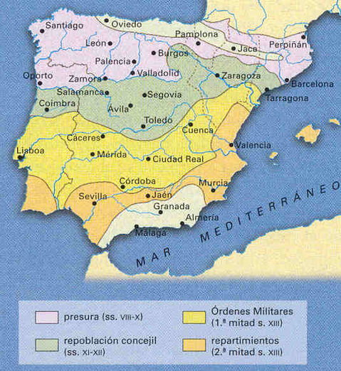
ANALYSIS OF A HISTORICAL MAP.
1. Classification
Type of map:
This is an evolution and political map that reflects the four methods which
were used to control the land conquered and establish the political, economic
and social structures of the Christian kingdoms during the “repopulation”
process.
Title: The
“repopulation” process of the Christian kingdoms.
Geographic space represented: On the map we can see the Iberian Peninsula.
Chronological period: since the 8th century
and the 13th century on the Reconquest.
2. Description and Analysis
Description: On the map we
can observe in purple in the Duero
Valley and Plana de Vic populated used
the methods of the aprisio or presura; in green between Duero and Tajo valleys , the lands populated
through the concession of fueros; in
yellow between Tajo and Guadiana valleys and the upper Júcar and Turia
valleys the lands populated by the military orders and in orange in the Guadalquivir and Mediterranean coast the lands distributed among those who helped
conquer this territory (repartimientos of donadíos
and heredamientos).
Analysis:
The small groups of Christians
who didn’t accept the authority of the Muslim conquerors took refuge in the
mountains areas of the North of the Iberian Peninsula and as time went by new
Christian States appeared in different parts of the peninsula. These States
were the origin of the Christian kingdoms which led the so called “Reconquest”,
developed in several stages, depending on the situation of Al- Andalus. Until
the 11th century few territories were conquered, but after the
disintegration of the Caliphate of Córdoba the Christian advance started and so
did the repopulation.
On the 11th they
conquered Toledo, Tarragona and Huesca. On the 12th century Castile
and León went through complicated times and Portugal became an independent
kingdom. The Crown of Aragon was created in the Pyrenean region and Navarre definitely
separated from Aragon. On the 13th century Portugal and Castile
conquered all the Guadalquivir Valley and Aragón reached the Baetic Mountains
and extended its expansion to the Mediterranean Sea.
After conquering the
territories, the Christians imposed their political structures and economic
system of exploitation. This is called “repopulation”, although the lands
conquered were not depopulated. This process was different depending on the power
of the monarchs, the nobles and the Church, and also with respect to the
treatment given to the Muslim population who fell in the hands of the
conquerors. Taking this into account, there were four different methods of
repopulation that we can observe on the map:
- -
In the first moments of the Christian advance, it was
common that free peasants or monasteries seized land spontaneously and started
exploiting it without any control from the kings. This process was called presura in Castile and aprisio in the Pyrenean area. On the map
we can see that this was done in Duero Valley and Plana de Vic.
- - Later in the repopulation of the lands between Duero
and Tajo valleys kings gave fueros
(charters of liberties) to the cities in the border areas to attract
population.
- - In other cases kings gave land to the military orders.
This way of population was used especially between the Tajo and Guadiana valleys.
The military orders of Santiago, Calatrava, Alcántara and San Juan were in
charge of populating these areas in Castile and the order of Montesa populated
areas of Valencia.
- - In other cases kings gave land to the people who
settled down in the conquered territories. In Castile, the kings gave big plots
of land to the nobles who helped them and this is the origin of the large
estates of La Mancha, Extremadura and Andalucía (donadíos and heredamientos
in the Guadalquivir Valley). In Aragón the kings gave smaller plots of land to
the nobles who helped them.
The repopulation meant
the establishment of the political and economic structures
of the Christian kingdoms in these territories: monarchy, estate-based society,
feudalism, peasants submitted to the privileged, subsistence economy…
3. Conclusion
Repopulation allowed the
control of the conquered land. The system of repopulation was different in each
zone depending of the circumstances, necessities and the time which passed and
they were able to improve the methods.
The consequences of the
repopulation that we can relate with the map could be the linguistic division
of the Valencian Community, populated by Aragonese, are Castilian-speaking
areas, as well as the structure of the property of the land still visible at
present (in the 2nd half of the 19th century) (large
estates in Extremadura, Castile La-Mancha and Andalusia, small properties in
the North and East...).
Phases of the Roman conquest

This map represents the Roman conquest of the Peninsula between the years 197 BC and 29-19 BC. The key map show us the first Scipios’ advance, ScipioAemilianus’ campaigns, Viriatus campaigns, the Lusitanians’ campaigns and the main Romans campaigns.
Classification
Phases of the Roman Empire is an evolution map, reflects the different stages of the Roman conquest in the peninsula between the years 197 BC and 29-19 BC. And is also a political map because shows the expansion of the Roman Empire in the peninsula.
Description and analysis
On the map we can observe how the Romans conquered more territories with each campaign and the different colours show the territories conquered until a specific year.
The first conquests until year 197 BC in green extended to the Mediterranean costs until the Gulf of Cadiz; these territories were occupied after the Scipions advance.
Then we have the conquest until year 154 BC in yellow where the borders expand West, after Viriatus’ resistance and Scipio campaigns the conquest of the Roman Empire until year 29 BC in pink expanded to almost all the peninsula with the exception of the North of the peninsula, where the territories of the Astures and the Cantabri were still untouched. By 19 BC in red, after some Roman campaigns ran by Augustus what was left of the peninsula was conquered.
The map refers to the conquest of the Iberian Peninsula; we can find reflected here all the stages of the roman conquest.
1st stage (218-187 BC), when two armies disembarked in Emporion because they were asked for help, started fighting against the Carthaginians. As the commanders in charge died at war fighting against Hasdrubal Barca in 210 BC, the Roman Senate sent P.Cornelius Scipio Africanus, whose actions were decisive for the Carthaginian defeat: the Romans took Cartago Nova in 209 BC; their troops defeated the Carthaginians at the battles of Baecula in 208 BC and Ilipa in 206 BC. In year 197 BC the Romans divided the Peninsula into two provinces.
2nd stage (154-133 BC), the Romans fought against the Celtiberians and the Lusitanians. The Lusitanians revolted against the high taxes imposed by the Romans and found a leader, Viriatus, who obtained some victories over the Romans between 147 And 139 BC. Finally, peace was signed, but the Romans bribed three Lusitanian warriors, who killed Viriatus in139 BC. The war against the Lusitanians extended for almost 20 years. Numantia became the main center of the resistance. The arrival of general P. Cornelius Scipio Aemilianus, who had destroyed Carthage, in 134 BC changed the situation. He sieged Numantia, building a nine kilometer fence around the city and cutting all its supplies. After 13 months the Numantians had no other choice than surrender. The few survivors were made prisoners and sold as slaves. The legend says that the Numantians burnt the city because they preferred to die free rather than live and be slaves, but this is not true. Roman historians used Numantian resistance to glorify Scipio Aemilianus triumph and the legend spread and was also used in other stages in the history of Spain to extol the sacrifice of the life of individuals in defense of the homeland. At the end of the Celtiberian and Lusitanian wars the Romans controlled the centre and West of the Iberian Peninsula.
3rd stage (29-19 BC), wars against the Astures, Cantabri and Gallaeci. Emperor Octavian Augustus arrived in the Peninsula to complete the conquest of Hispania and take the control of its rich mineral resources. He deployed 8 legions and several auxiliary troops (50,000 soldiers), opened a 400 km front, from the Pyrenees to Portugal and defeated the Cantabri, the Astures and the Gallaeci.
After Augustus campaign, Hispania became another part of the Roman Empire and its integration is shown in the demilitarization and reduction of troops on the ground and the little information provided by Roman sources about Hispania.
Conclusion
In this case the map reflects the phases of the Roman conquest on the Iberian Peninsula. The map is important to understand how the Romans conquered the peninsula, the time it took them and the campaigns they had to organize the whole conquest of the Peninsula, it also reflects how the northern populations were more resistant to the Roman invasion, helped by the geographical environment, protected by the mountain ranges, and how this repeats throughout history with all the invasions the peninsula has suffered, always the northern towns were the last to be conquered or not. This meant the total incorporation of the Peninsula to the Roman Empire and it became a province of Rome, called Hispania.
Territorial unification of the Visigoths
1- CLASSIFICATION
This is an evolution map which represents the main stages of the territorial unification of the Visigothic Kingdom of Toledo (507-711). According to the topic represented, we can say that it´s a political map that represents the different states and territories of the Iberian Peninsula during the 6th and 7th centuries.
2- DESCRIPTION AND ANALYSIS
We can see that the territory of the Visigoths is represented in yellow, the territories of the Basques, Cantabrians and Franks in purple, the Kingdom of the Sueves in red and the province of Spania (Byzantine Empire) is represented in green. Also, we can observe some arrows that represent the different military campaigns launched by the Visigoths.
The map shows the process of territorial unification of the Visigothic kingdom of Toledo made mostly by the kings Liuvigild (568-586) and Suintila, who defeated the Byzantines, annexed the territories of the Sueve Kingdom and defeated the Basques and Cantabrian peoples.
We can observe the most important military campaigns launched by the kings Liuvigild and Suintila:
In 571, during king Liuva’s reign, his brother Liuvigild, who was in charge of the province of Septimania, launched a military campaign against the Byzantines, who had conquered some territories of the south and east of the Iberian Peninsula and created a province called Spania during Justinian’s rule. After the death of his brother Liuva, Liuvigild took the control of the Visigothic Kingdom and launched several campaigns to achieve the territorial unification of the Peninsula under the rule of the Visigoths.
After being proclaimed king in 572, he launched an expedition which lasted 9 years (until 582) and finally defeated the peoples of the north (Basques and Cantabrians), but, as many other times, this territory wasn´t completely socially and politically integrated in the state and had a lot of difficulties to control (we can't forget that these territories were the last territories to be controlled by the Romans, the only ones that weren't conquered by the Muslims and where the Franks were defeated) .
In 584, he launched a military campaign to the north-west of the Iberian Peninsula and defeated the Kingdom of the Sueves annexing its territory to his Kingdom.
Finally, we can see the two last military campaigns launched against the Byzantines by Suintila after the death of Liuvigild. After the expeditions in 616 and 618, the Visigoths reached their objectives, expelled the Byzantines and unified all the territories of the Iberian Peninsula under their rule.
3- CONCLUSION
We can emphasize the importance of this map to understand the period of unifications of the Visigothic kingdom, together with the other two unifications: the religious unification, made by Reccared in 585 and the legislative unification, made by Chindasuinth and Recceswinth with the Liber Iudiciorum in 654; and to understand some of the subsequent events of this period.
Also, we can say that this territorial union didn't last for long time, because the constant succession conflicts between the nobles caused the subsequent invasion of the Muslims in 711.

The Muslim conquest of the Visigothic Kingdom (corrected)

-CLASSIFICATION
This map is an evolution map which reflects the situation of the Peninsula when the Muslims invaded it. Is a Socio-political map, because it shows the expansion of the Muslims and the territories that belonged to the Christians.
The title of this map is “Military campaigns”. It’s a map of the Iberian Peninsula during the chronological period between 711 to 732. The map key shows different military campaigns. It’s a contemporary map made to explain things referred to the past.
-DESCRIPTION AND ANALYSIS
Description: On the map we can observe the different territories which were conquered by the Muslims and the territories kept by the Christians between 711-732. The map also shows the different military campaigns with arrows in different colours. There is also a symbol which shows the main battles.
In yellow are the territories occupied by (under the power of) the Muslims and in purple the ones that remained in the hands of the Christians in the first moments of the conquest. In the north in white we find the territories that were not occupied by the Muslims and remained in the Christians’ hands.
Analysis: the map explains the end of the Visigothic Kingdom and Muslim conquest of the Iberian Peninsula
The invasion was possible because when Agila was displaced from the throne, his relatives looked to the North of Africa and sent emissaries there to get their help to expel king Roderic from the throne. The different arrows show the different military campaigns developed by several Muslim armies: In blue, the first army arrived in 711, commanded by Tariq ibn Ziyad, which disembarked in Gibraltar and defeated the Visigothic troops in the Battle of Guadalete, where King Roderic died. After this, the Muslims didn´t give the throne to Agila, and they decided to stay in the Peninsula. In 712 another army commanded by Musa ibn Nusayr represented with a red arrow, arrived in the Peninsula, joined Tariq´s troops in Toledo and they conquered almost all the territory. In 721 the Muslims reached Septimania, in the South of Gaul. The Visigoths didn´t put much resistance. Some people signed surrender agreements, like Theodemir of Orihuela, whose territory appears in purple, who signed the Treaty of Orihuela and converted to Islam (Tudmir was his Muslim name). He and other Visigoths in different parts of the Peninsula did this because they wanted to keep their properties. In the North of the Peninsula, the map shows the territories under the Christian power. In this period there were also two important battles, which are reflected on the map:
- In 722 the Battle of Covadonga, in fact a skirmish, where the Muslims were supposedly defeated by an Asturian man called Pelagius
- In 732 they were stopped in France by Charles Martel, in the Battle of Poitiers
After these two battles the Muslims settled down mainly in the center and South of the Peninsula and established an emirate, depending from the Caliphate in Damascus.
The Muslims stayed in the Peninsula for 8 centuries, until the Christians "reconquered" the Peninsula, after deposing the last Nasrid king of Granada in 1492.
-CONCLUSION
The map reflects the Muslim conquest of the Peninsula during 711-732 in the Iberian Peninsula.
As for the historical significance of this map, we can relate it to know the beginning of the conquest and the origin of Al-Andalus. The Christian territories in the North were the origin of the Christian kingdoms which begun the “Reconquest”.
Map about the expansion of the Crown of Aragon in the Mediterranean Sea (13th-15th centuries).

1.CLASSIFICATON
-Type of map:
It is a situation map, because in this map we can see the territories that belonged to Aragón during a period of time, the Late Middle Ages (13th-15th centuries)
It is a situation map, because in this map we can see the territories that belonged to Aragón during a period of time, the Late Middle Ages (13th-15th centuries)
And it is a
political map, because in this map we can see the conquests or the expansion(s)
of the Crown of Aragon.
-Title: The expansion of the Crown of
Aragon in the Mediterranean Sea (13th-15th centuries)
-Geographic space
represented: On the
map are represented the different territories of the Mediterranean coasts, In
the west and north we can see the Iberian Peninsula, the Balearic Islands the French coasts, the Papal States, Naples,
Sicily and Sardinia, in the east, the Byzantine Empire and the Duchies of
Athens and Neopatria and in the south (North of Africa) Barbary
States. In the map we can also see the Mediterranean Sea and Central Europe
(Holy Roman Empire).
-Chronological period: In the
Late Middle Ages during the 13th and 15th centuries that were the period in
which these territories belonged to Aragon.
2.DESCRIPTION AND ANALYSIS
DESCRIPTION
On the map we can observe the coasts of the
Mediterranean Sea, in the west, the Iberian Peninsula (formed
by the crown of Castile, The Crown of Navarra and the Crown of Aragon), and we can
see the main empires of these centuries, like the Holy Roman Empire, The
Byzantine Empire in Europe and the Barbary States in Africa.
As we can see in the map, which
represents the positions of the Crown of Aragon during this period, the places
that Aragon conquered and the crown of Aragon too are represented in yellow.
The places that Aragon added to its territory were the Balearic Islands, the
territories of Roussillon, Sicily (which was conquered by Peter III the Great
in 1282), The duchies of Athens and Neopatria (conquered by the Almogavars in
1311 and 1319), Sardinia (conquered by James II in 1323) and Naples (conquered
by Alphonse the Magnanimous in 1442).
You can see perfectly the dates of the conquests in the map.
And on the map the capitals or major cities
of each kingdom are marked with an orange dot, like for example in the crown of
Aragon, there is Zaragoza, in Sicily there are Palermo and Syracuse in the
Duchies of Athens, there is Athens etc…
-Analysis:
At the beginning of the 9th century, the
Carolingian Empire disintegrated and appeared three new regions: Kingdom of
Pamplona, Catalan counties and Aragonese counties. Aragonese counties fell
under the influence of Navarre. At the beginning of 11th century
Navarre was he most powerful Christian country: King Sancho III the Great
created a big kingdom included Castile, Aragonese counties and had a big
influence in Leon. When he died, he divided his kingdom among his sons. Aragon
was for his son Ramiro I. In the second half of this century Navarre was added
to Aragon that was united between 1076 and 1134.
On the 12th century in the Pyrenean region the Crown of Aragon was
created, with Petronila of Aragon and Ramón Berenguer IV of Barcelona’s
marriage. From its origin, every part of the crown kept its laws and
institutions and the monarchs had to accept and respect them. When Valencia was
added to the crown, this principle persisted and the Crown was consolidated as
some kind of confederation made up three different territories in the peninsula:
Aragon, Catalonia and Valencia.
Aragon’s traditional intervention in the South of
France stopped with James I. His father Peter II had died at Muret in 1213,
fighting to defend his subjects in Provence from the French intervention to
crash the Cathars, declared heretic by Pope Innocent III. James I oriented the
expansion to the South and the Mediterranean Sea. The conquest of Valencia
(1238 – 1245) and Mallorca in 1287
In 1244 the Treaty of Almizra was signed between James
I of Aragón and his future son-in-law Alphonse X the Wise of Castile. They
definitely set the limits of the Kingdom of Valencia and agreed on the cession
of Murcia to Castile. This treaty was signed after the unfulfillment of
previous treaties between Castile and Aragón, signed to establish the borders
of both kingdoms (teatries of Tudilén in 1151 and Cazola in 1179). After the
inclusion of Murcia in Castile, the crown of Aragon oriented its expansion to
the Mediterranean Sea.
Different territories were added:
-
Sicily, conquered by Peter III the Great
-
the
duchies of Athens (1311) and Neopatria (1319) in Greece (conquered by the
Almogavars, mercenary troops who fought in the Byzantine Empire)
-
Sardinia (1324),conquered by James II
-
and Naples (1442) conquered by Alphonse V the
Magnanimous in 1442.
The orientation to the Mediterranean Sea was not
equally accepted by the different parts of the Crown. During Peter III’s reign
the Aragonese nobles (created a brotherhood called Aragonese Union).
Peter III had to accept respecting the particular laws
of Aragon, call the Cortes
periodically and promise not to start any foreign intervention without
consulting the Cortes. Apparently this was a victory for the nobles, but in
1347 Peter IV defeated the Aragonese nobles, who had defied him, in the Battle
of Épila and ordered the destruction of the Privileges of the Union. On the
other hand, the constant need for the money to finance the wars led to the
creation of some permanent institutions in the Cortes to control the expenses
of the money given by the Cortes to the king; the Generalitat in Catalonia (1358) and Valencia (1418) and the Diputación General in Aragón (1436). In
this way, the tradition of balance between the monarchs and their privileged
subjects was kept.
This expansion contributed to its economic
development, especially during the first half of the 14th century:
craftsmanship and trade expanded, consulates were created in different parts of
the Mediterranean to solve conflicts with trade and the Aragonese ships and
merchants competed with the Venetians and the Genoese in the Western
Mediterranean. This prosperity broke up with the Black Death epidemic, with
strongly hit the Crown of Aragón.
CONCLUSION
In this case, the map reflects the
territories that belonged to Aragon during the 13th and 15th centuries and the
routes that Aragon followed to conquer these territories. These conquests started
when James I oriented the expansion to the South and the Mediterranean Sea.
As for the historical significance of
the map, we can relate it to economic development of the Crown of Aragon and
the Hispanic Monarchy intervention in Italy during the Modern Era (the Catholic
Monarchs and Charles V’s reign). This Mediterranean empire obliged the monarchs
to fight in several wars against their traditional enemy (France) and had a
high cost in lives and money.
Wednesday, December 3, 2014
Map about the third stage of the "Reconquest"

ANALYSIS OF HISTORICAL MAP
It is an evolution and political map, which reflects the different stages of the period we known as “Reconquest”, in the Middle Ages in the Iberian Peninsula.
It shows the second stage of the “Reconquest”, which took place between the 11th and 13th centuries. It describes the Christian advance, taking advantage of the Muslim's weakness.
DESCRIPTION
On the map we can observe the borders of the Christian kingdoms in 1150, which include the North half of the Iberian Peninsula. Dark colours represent the extension of the Christian Kingdoms before the conquests of the 13th century: dark green belongs to Portugal’s territories, dark orange to those of Castile and dark purple to the Crown of Aragon’s extension. It shows the territories conquered by the Kingdom of Aragon: Valencia (1236) and Mallorca (1229-1232) in light purple; those conquered by the Kingdom of Castile in light orange: Cáceres 1214), Badajoz 1228), Córdoba 1236), Jaén and Seville 1248); and finally, those conquered by Portugal in light green: Tavira (1238).
Besides, the main battles appear in the map: the Battle of Alarcos (1195), the Battle of Las Navas de Tolosa (1212) and the Battle of River Salado, which took place in 1340.
We can also see the borders of the Nasrid Kingdom of Granada around year 1257, which extended to the present provinces of Almería, Granada, Málaga and part of Cádiz.
The map also includes different readjustments of the borders between the 13th and 15th centuries, as well as the expansion of Catharism in the South-West of France in 1200 and the Catalan-Aragonese influence in Occitaine in 1258.
ANALYSIS
This map reflects the process of the “Reconquest” in the 13th century. The “Reconquest” is a term used to refer to the advance of the Christian kingdoms of the North of the Iberian Peninsula to the South. It was rather the conquest of the territories occupied by the Muslims by the Christians kingdoms of Aragón, Portugal and Castile. It has its origins in the 9th century, the kings of Asturias and León established a continuity with the Visigothic Kingdom. Since the 11th century, the conquest added a connotation of “crusade” against Islam.
It started after the disintegration of the Caliphate of Córdoba and the military weakness of the Taifas kingdoms.
The “Reconquest” has three stages: the first one took place between the 8th and 10th centuries, when there was a Muslim superiority
The second stage took place between the 11th and the middle of the 13th century and it includes the Christian advance. Finally, the last stage, which is the one reflected on the map, took place between the middle 13th century and the end of the 15th, in period in which the Nasrid Kingdom of Granada survived through the payment of parias, when it was defeated by the Catholic Monarchs.
After the disintegration of the Almoravid Empire in 1145, Alphonse VII of Castile and León conquered Almería in 1147 and Alphonse VIII of Castile conquered Cuenca in 1177. This advance was stopped by the Almohads, a new people from the North of Africa, who had crossed the Gibraltar Strait in 1147 and reunified the Taifas kingdoms, except for Mallorca, which survived under Almoravid rule until the end of the century. In 1195 Alphonse VIII of Castile’s troops were defeated in the Battle of Alarcos, in present Ciudad Real. The Castilians were obliged to sign a truce with the Almohads. After this victory, the Almohads reconquered several places, such as Trujillo, Cáceres, Plasencia, Talavera, Cuenca and Uclés.
Alphonse VIII of Castile led a coalition of Christian princes and monarchs against the Almohads, who were defeated in the Battle of Las Navas de Tolosa in 1212. This Christian victory opened path to the conquest of the Guadalquivir Valley. Although the Almohad Caliphate didn’t fall immediately, Portugal and Castile conquered all the Guadalquivir Valley and Aragón reached the Betic Mountains.
Alphonse IX of León conquered Cáceres in 1227 and Badajoz in 1230; Ferdinand III the Saint of Castile and León conquered the main cities of the Guadalquivir Valley: Córdoba (1236), Jaén (1246) and Seville (1248) and James I the Conqueror of Aragón conquered Mallorca (1229) and Valencia (1238). Alphonse III of Portugal conquered Faro in 1249 and finished the Portuguese expansion
After Peter II’s death at the Battle of Muret in 1212, who was fighting against the French to defend his subjects, the Crown of Aragón orientated the expansion to the South and the Mediterranean Sea. After the signature of the Treaty of Corbeil in 1258 and the inclusion of Murcia in Castile, the Aragonese renounce to intervene in the South of France and explains their expansion in the Mediterranean sea.
After the big conquests of the 13th century, the Nasrid kingdom of Granada was the only Muslim territory that remained in the Iberian Peninsula. It survived until 1492, when it was finally conquered by the Catholic Monarchs.
The conquests were accompanied with the occupation of the territory (“repopulation”) and the extension of the political and economic structures of the Christian Kingdoms in the former lands of Al-Andalus.
CONCLUSION
The map reflects the last stage of the process known as “reconquest”, (which was a decisive process for the stop of the Islamic advance in Europe), which meant the end of the Islamic presence in the Iberian Peninsula, after eight centuries.
As for the historical significance, as it was a large process which lasted around 700 years, we can find, for example, a lot of remains of Hispano-Islamic art, above all in the South of the Peninsula. Its main examples are Córdoba’s mosque and the Alhambra of Granada.
Moreover, the Christians kingdoms established their political and economic structures to the territories that had belonged to the Muslims: the Muslim conquest had interrupted the feudalization process developed in Europe, but feudal relations spread in the Christian States and extended as the conquest went by. Subsistence economy also developed and agriculture which was the main economic activity, introduced the more modern techniques and crops that the Muslims had introduced.
Subscribe to:
Posts (Atom)